City Councilwoman says rumors of eminent domain in North Side ‘not true’
Jeremy M. Lazarus | 7/27/2023, 6 p.m.
A hoax that created a small uproar over the Richmond leg of the $266 million regional Fall Line Trail is being dispelled.
The uproar began when residents along the north side of Brookland Parkway began receiving letters last week that purportedly came from the Norfolk-based Lollar Law and stated that their front yards would be taken by eminent do- main for the trail.
After receiving multiple calls, City Councilwoman Ann-Frances Lambert, said Monday that residents living on Brookland Parkway between Brook and Hermitage roads are being reassured “this information is not true.”
Brookland Parkway does not appear to be part of the trail’s route in Richmond.
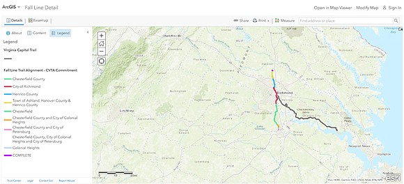
According to a video that Richmond Sports Backers has created on the trail’s route, the trail would use the bike lanes on Brook Road after leaving Jackson Ward and then use a stretch of Bellevue Avenue to get to Bryan Park, which then serves as an entry to the Henrico County section.
Ms. Lambert indicated that the letters did not come from either state, regional or local authorities.
The law firm did not respond to a Free Press request for information on whether the firm generated the letters.
City administration officials also did not offer any information about the letters or the trail’s design.
Already approved, the first section of the trail is now under construction in Hanover County.
When complete, the trail is to run 43.6 miles between Ashland and Petersburg, ending at a park on the Appomattox River. To be paved, the Fall Line, in part, will knit together an existing network of trails.
In the city, the trail is to run between Bryan Park and Falling Creek on the border with Chesterfield County, and run on existing streets through Jackson Ward and Downtown. The T. Tyler Potterfield Bridge at Brown’s Island is to serve as the crossing point for the James River.
Meanwhile, Henrico County’s Fairfield District, which also is a part of the Fall Line Trail, hosted a public meeting on May 16 at Lewis Ginter Botanical Garden to inform residents about the trail’s construction scheduled to start in May 2025, according to the county’s website.
The Fairfield District’s part of the trail will see approximately 2,800 linear feet of a minimum 12-foot wide multi-use trail that will be constructed along the north side of Hilliard Road and the west side of Brook Road from the northern end of the Lakeside Community Trail, Phase 3 to the intersection of Lakeside Avenue and Brook Road, according to the county’s website.
Right-of-way acquisition was to start in Henrico this month, utility relocations are to start in January 2024, advertisement for construction is anticipated September 2024.
The Virginia Department of Transportation is overseeing the trail’s development.
For more information, visit https://www.falllineva.org/trailmaps


