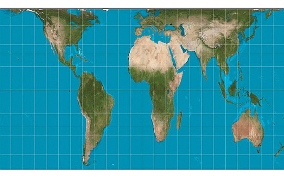
World map shows Africa in truthful light
4/13/2017, 7:09 p.m.
Trice Edney News Wire/Global Information Network
In an age of “fake news” and “alternative facts,” authorities in the city of Boston believe their new school map offers something closer to the geographical truth than that of traditional maps, and hope it can serve as an example to schools across the nation and the globe.
The school district will drop the Mercator projection, which physically diminished Africa and South America, for the Gall-Peters projection, which cuts the developed world down to size.
The Gall-Peters projection shows land masses in their correct proportions by area, putting the relative sizes of Africa and North America in perspective.
So when Boston Public Schools introduced a new standard map of the world this week, some young students felt their world had changed.
The United States of America was small. Europe, too, had suddenly shrunk. Africa and South America appeared narrower but also much larger than usual. And what had happened to Alaska?
For almost 500 years, the Mercator projection — designed to aid navigation along colonial trade routes — has been the norm for maps of the world.
In the Mercator system, North America and Europe appear bigger than South America and Africa. Western Europe is in the middle of the map.
South America is made to look about the same size as Europe, when in fact it is almost twice as large, and Greenland looks roughly the size of Africa when it is actually about 14 times smaller. Alaska looks bigger than Mexico, and Germany is in the middle of the picture, not to the north.
The switch to the Gall-Peters projection sees Boston’s public schools follow the lead of the United Nations, which has advocated the map as a more “fair,” less Eurocentric representation of the world, as have several aid agencies.
Teachers in the second, seventh and 11th grades already have received their new maps, and say the reaction from their students has been fascinating.
“It’s interesting to watch the students saying, ‘Wow’ and ‘No, really? Look at Africa, it’s bigger,’ ” Natacha Scott, director of history and social studies at Boston Public Schools, said.
“Some of their reactions were quite funny,” she added. “But it was also amazingly interesting to see them questioning what they thought they knew.”


