8,000 potential gravesites identified at East End Cemetery using drone and hydrology mapping software
Jeremy M. Lazarus | 2/24/2022, 6 p.m.

Finding unmarked graves in neglected cemeteries has always been a challenge.
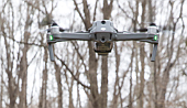
Now a Richmond research team has created a relatively inexpensive method to simplify the search using a drone — an increasingly favorite tool of archaeologists — and standard mapping software for water movement or hydrology.
As detailed in a newly published article in an international journal, the team successfully tested the method in East End Cemetery, a historic Black cemetery located on the eastern border of Richmond and Henrico County within a complex of private and public graveyards that includes the city’s Oakwood Cemetery.
The team identified at least 8,000 potential gravesites in East End Cemetery, many previously invisible due to the uneven terrain that also is full of trees, according to the article in the International Journal of Historical Archaeology
According to the team, the data generated from the more than 800 photographs taken by the drone and that were run through the mapping software created “a plausible repre- sentation of potential grave locations.”
Describing the initiative as a “relatively cheap, simple and quick mapping method,” the team expressed the hope that their innovative approach can be “implemented to assist in reclaiming historically under-funded Black cemeteries across the American South.”
The team’s members include Dr. Ryan K. Smith, a Virginia Commonwealth University history professor and cemetery expert, and Dr. Stephanie A. Spera, a University of Richmond assistant professor of geography and the environment.
The two other team members are Elizabeth A. Zizzamia, GIS manager of the University of Richmond’s Spatial Analysis Lab, and Matthew S. Franklin, a UR student and now a GIS specialist with Timmons Engineering.
Dr. Spera credited Mr. Franklin with coming up the idea, based on his experience of using a drone to hunt for Viking sites in Canada.
She said that she and Mr. Franklin experimented with other mapping software before finding that the hydrology software was the right fit for identifying graves, due to water pooling in indentations.
Dating to 1897, East End Cemetery borders the older, larger and equally historic Evergreen Cemetery, both of which are now under the oversight of the Enrichmond Foundation, a city-based nonprofit.
Estimates are that more than 15,000 people were buried in East End Cemetery, which remained largely untended for decades and had its last burial in 2002. Volunteers who later organized into the Friends of East End Cemetery found 3,340 marked graves in seeking to reclaim the graveyard. The group has created a website that provides the locations of those burial sites and also provides links to articles and information about the individuals where known.
However, as the team noted, many of the graves in the cemetery never were marked. Also, through the decades, temporary markers were lost or destroyed, burial records disappeared after the original East End operation dissolved in the 1950s and trees, vines and plant growth left the ground uneven. Essentially, those graves that did not have markers disappeared.
According to the team, East End Cemetery is just one example of the historic Black graveyards that have been largely abandoned and become overgrown.
One reason is that earlier private Black cemeteries almost never charged the kind of fee now typical to provide for perpetual care. And for decades, Black cemeteries never received any public support.
In Virginia, the state provided support for groups tending Confederate cemeteries until a recent major change ended the practice and shifted the funds to Black burial grounds created before the 20th century.
Far more expensive methods have been previously used around the globe to find grave sites, such as satellite imagery and ground-penetrating radar, but the team believed that drone photography — already used in Siberia and Kyrgyzstan to find burial sites — could simplify the search.
While drones can be loaded with expensive sensors and other equipment to help improve imagery, the team found that advances in both hardware and software could provide the quality, detailed images that are required for such work and that those advances made the initiative possible even for those lacking expertise in engineering or image processing.
After the drone’s images were downloaded, the team reported that only six hours were needed to run them through hydrology-based mapping software and, with tweaks, identify possible grave sites. The team then checked a sample of 12 percent of the thousands of sites they believed held graves to ensure they were on the right track.
Compared with other methods, the cost was minimal, totaling about $6,600, the team reported.
The team estimated that it could cost more than $120,000 to use ground-penetrating radar to cover the 16-acre cemetery, without certainty that the radar would find remains. It also would cost more than $10,000 to equip the drone with more expensive sensors.
The results they gained are imperfect, the team acknowledged, and limited to areas where the drone could easily photograph without interference from trees and their leaf canopies that cover much of East End Cemetery’s burial grounds during the late spring, summer and early fall.
Despite the limitations, the team believes their approach represents a major step forward in locating graves and reclaiming burial grounds.